Showing posts with label Owens Valley. Show all posts

Tuesday, September 23, 2008

Make It Stop! - Tuesday 9/23/2008


"Oh my gosh. It's 9:50 in the morning and we are still in Lone Pine!" is the post I started to write this morning.

We went into town to gas up the Tahoe before heading out across the desert, get a last cup of coffee at the coffee house and give in to the the simple lure of McDonald's Sausage McMuffin with egg. Thus one last photo of a nice sign in Lone Pine.

Back to the campground, finished packing up. Hooked up the trailer (which in itself takes about 15-20 minutes.) I took one last walk around the rig to make sure the windows were closed, steps were folded up, brake lights are working...and discovered that the Tahoe's back right tire was visibly flat.

We unhooked the trailer and tried to change the tire ourselves. The jack comes in about 12 pieces stored in a compartment of the truck. You have to unlock the spare tire with a key. Then the diagram didn't look anything like the way our tire was suspended between the back wheels.

So we called AA and settled in for a wait.

The guy came (from the same place with the Angry Mechanic) right away and fixed us up.

We just have to be really really glad that neither of these things happened when we were in the middle of the Mojave, which would have just complicated everything. A lot.

Dodger said "Home" for the first time this evening when we were done unpacking and I was working for my job. (From 4-10 p.m. Sigh.)

So we have two weeks to get the catalytic converters replaced... Is what I'm pretty sure I was going to say!

Sunday, September 21, 2008

Hanging Out at Boulder Creek - Sunday 9/21/2008


We spent last night sitting outside the trailer singing to Hydra's guitar playing. The neighbors were really friendly and even came over to tell us how much they enjoyed it.

I went out again in the morning with Dodger. He likes watching what's going on. He was out here in the dark last night, too.


How do you get nice trees like these next to our campsite in the desert? By irrigating twice a day, in summer.


I chatted with the camp's owner in the morning when we indulged in the free muffins and coffee, and told her we were a bit stranded. She offered us the use of a loaner car that they keep here, at Lone Pine's little airport.

"Just go in and let Red know you need the car," she told us, and got one of her employees to take us the couple of miles over there. She didn't have much nice to say about the Angry Mechanic, either.

Saturday, September 20, 2008

In Which Sundry & Hydra are Ferried About Town - Saturday 9/20/2008 (Part Three)

Also in which Sundry and Hydra never make it to Hydra's birthday lunch in Indepedence, opting to have their Tahoe slowly lose power and die in a red zone at the edge of Lone Pine, CA. Pop. 1665, elevation 3733.

We met a nice man who stopped to see if he could help. And a nice sheriff who looked about 26 years old checked to make sure we were okay while we waited for the AAA tow back to the garage we'd already talked to.

They'd have to do a bunch of work, and they were about to close until Monday. I don't want to go into the gory details of the difficult conversations with the angry mechanic, who is the only mechanic in town, who everyone says overcharges.

Also in which we find out how a photographer entertains herself while waiting for a tow.

This is outside one of the public buildings in Lone Pine, across from the film museum. You're instructed to look through the pipe to see Mount Whitney on a clear day.

See it?


View of Mount Whitney on a cloudy day.

We heard several people look through this and laugh as we sat there...waiting.


Dee dee dum. Oh, look at the cool thing that has fallen from the tree overhead!


Our ride arrives.

We are simultaneously thrilled and frightened to find that we have to ride inside the Tahoe while it's being transported on the back of the truck!

We've never been down this road before! (Neither has the Joy Luck Duck, seen here hanging on for dear life.


Hydra waves like the queen as we are carried past the homes of those who have to actually drive their vehicles from one place to the other.


Our destination for the time being. Sigh.

We got a ride back to the campground, about five miles away, with a woman associated with the shop somehow. Maybe angry guy's wife.

She said her great grandpa Bill built the shack on top of Mount Whitney.

Whitney Portal Hike - Saturday 9/20/2008 (Part 2)


We ventured up to Whitney Portal, the place where fearless mortals begin their climb to the top of the tallest mountain in the contiguous U.S., Mount Whitney. So cool that WPA workers built this trail for us in the 1930s. What a great thing the WPA was.


Hydra enters the breach. The big rocks make me feel like a little kid!


Hydra overcomes his usual shyness and busts loose with some melodrama.


Falls at Whitney Portal.


Here we go, about to drop about 5000 feet in 13 miles. This is the road that is going to put the Tahoe in the hospital.


A view of the Alabama Hills from Whitney Portal Road.

Return to Manzanar - Saturday 9/20/2008 (Part 1)

We visit the Manzanar National Historic Site every time we're in the Owens Valley, which is once or twice a year for the past eight years or more. They've been slowing adding information and restorations, including a really wonderful interpretive center.

If you're traveling through you really must stop and explore.

This is the entrance to the graveyard. People have hung origami figures all around it.


The central monument in the graveyard.


People put mementos on the monument. This apple came from one of the trees in the orchard here. Manzanar means orchard in Spanish. There was a very small town here by that name around the turn of the 19th Century.


One of the baby graves.


The ranger at the interpretive center told us that they'd made progress in excavating Peace Park, one of several gardens built by the Japanese-American internees during their time at Manzanar. We'd seen the standing stones before, but the painted writing had worn away.

This is amazing! This was taken from the newly excavated basin of one of the intricately constructed ponds. Dirt used to come almost all the way up to the rocks and covered many of them. The site's much bigger than we realized from what used to protrude.

The ranger told us they'd removed as much as four feet of sand!


Elk tracks near Peace Park. They have the run of the place and it seemd like they might actually have been frolicking here earlier in the day!

Saturday, November 03, 2007

San Francisquito Canyon - Friday 11/2/2007


This is Power Plant No. 2 in San Francisquito Canyon. Those pipes are 6-8 feet in diameter each! I wish I could have gotten better pictures of the amazing architecture of this remote building, but in this post-9/11 era everything to do with utilities is hard to get to.

Mom and I took a drive today. Headed out Lake Elisabeth Road from Palmdale and ended up on San Francisquito Canyon Road, heading south.

I've had a long fascination with the Saint Francis Dam disaster of March 12, 1928, probably because the dam was built to contain water brought here via the Los Angeles Aqueduct from the Owens Valley. I dunno, I find big public works very moving... While they are impressive, they usually occasion great loss for a few people while creating something intended to provide a greater good to a large population (usually by investors and public officials who get to put their names on plaques.)

Anyway, it's called the greatest civil engineering disaster of the 20th century. More than 400 people died in the flood after the dam broke. Waters raged toward the ocean from this spot about 15 miles north of Saugus, through what's now Valencia, Fillmore, Santa Paula, all the way to Ventura.

Well, you can read about it yourself through the links above.


The thing that astonished me was that San Francisquito Road itself has been rerouted since I was there last! Has it been that long!?

I was driving along looking for this live oak tree and fence. That's where we used to park and walk back to the left of this shot to get to the fallen "tombstone" remains of the center of the dam. I really liked knowing how to find it by that tree. It's a wonderful canopy with a lot of space underneath...feels like it would be a great place to camp, if you could camp there.

We were there some time after the Copper Fire in 2002 and saw more of the dam exposed than we'd realized was still extant. Here are the old directions to the site.

Here are new directions to the site. This map and other information are posted at the fire station just south of Power Plant No. 2.

It was interesting to be out and about for the day. Pretty tiring. I guess the stamina is building bit by bit. I think returning to work next week is going to hit a little hard! Ah, but it's life!

Friday, September 28, 2007

Heading Home - Sunday 9/23/2007


Alas, the sun rises on Sunday morning and it's the day of our departure. The first night with no rain and look what the clouds left behind!


We went to the Totem Cafe in Lone Pine for breakfast with our friends. Lookit! Gary Cooper signed their Famous Wall!

We packed up and headed out a little before noon, a little before B&G. We had to drive a bit cautiously with the trailer because you just do, and because there was some gusty wind knocking us around a little. B&G passed us just beyond Pearsonville.


Guess what? B&G blew out a front left tire about a mile and a half from Red Rock Canyon. You don't even want to know. This was the third tire that blew out on this trip! They've now had to replace 4 of the 8 tires that were on this rig when they bought it three years ago.

Somebody at All Valley RV is going to get a talking to, you bet.


Telephoto lens catches Hydra and G walking north along the 14, trying to find the spot where B had cell phone connection right before the blow out. They got a connection, but it was the auto line rather than the RV line, and then it mysteriously dropped service. Aaaah. After about 20 minutes, they decided to catch a ride with us to Red Rock where B used the rangers' satellite phone to call AAA.

G moved the crippled RV by the time we got back to them, and was on a very difficult curve, stopped by the guard rail from going the last quarter mile to RRC. B was steamed. The place they'd originally stopped would have been decent to change a tire.

"I love him, but I'm going to kill him," she said as she got out of the Tahoe.

We went on, figuring we couldn't help any more and that they'd just feel bad about holding us up. I called their son and let him know they were okay when we got back in cell range. He'd been talking to B when the tire blew and coffee flew.

We were very very pleased with our decision to have replaced our cracked trailer tires the weekend before the trip.


Broken RV Vista Point.

Manzanar Revisited - Saturday 9/22/2007


We went out to Manzanar National Historic Site (World War II internment camp) late Saturday, after the interpretive center had closed. If you've followed the blog, you know we've been here before.

I don't know why we're so drawn to it. Maybe it's just the idea that 10,000 people lived here in barracks like these for a couple of years while their businesses languished and their former communities moved on without them.

Maybe it's also partly that when we first visited about 10 years ago, there was just a little sheet of paper noting various landmarks you could pick out, but which weren't very well marked. Now there's a wonderful interpretive center, a reconstructed guard tower (important, because there was actually a book available at the Lone Pine Drug Store that denied that anyone was kept here against their will or that there were even guard towers,) and signs that they are working to restore some of the water gardens created by the people who lived here.


We've been visiting this spot for years. Last year there was no sidewalk and some of the deepest pool was filled with dirt. I climbed all around it, because I suspect that by next time this will be fenced off. It looks like they're going to move the barracks over here, too, because there were unearthed (or recreated?) blocks of foundation concrete on either side.


Looking south past monument at the graveyard. Most of the bodies were moved to other locations when the camp was closed.


One of the interesting tributes left on the monument.


The grave marker of Baby Jerry Ogata.

Here's a link to the photos Ansel Adams took there, courtesy of the Library of Congress.

Tuesday, September 25, 2007

Later That Same Day - Thursday 9/20/2007


Pavement ends? You don't say. (Taken at Pearsonville, CA.)


The cinder cone in the middle of the road. When we go around this, I feel that we are really in the Owens Valley. (If you Google "Owens Valley" you'll get lots of hits about geology and history, etc.)


Pretty new sign painted on the old water tank. You can get tee shirts with this design on them.


The view from our campground, about two miles south of Lone Pine, CA. Not from our campsite, exactly, but from the road behind our campsite.

Wouldn't want to be climbing in those mountains today!

Monday, October 02, 2006

A Much Needed Day Outdoors - Saturday 9/30/2006

We ventured into the Alabama Hills again on Saturday. Hydra was busy with his metal detector, while I trundled up into one of the many spaces between rocks with my camera, notebook and a desert guidebook that was written in 1969. Some beautiful writing in the introduction, etc.


It was shady and cool between the rocks, and the loudest sound was my fountain pen gliding across the page.


This granite is so decomposed that you can actually crumble bits of the edges away with your bare fingertips.


We drove deeper into the hills in search of Gene Autry Rock. The road was quite narrow in some places. See how the side mirrors are folded back?


I hiked up a ways and did some rock-hopping. Love this boulder that dropped down and filled in the gap. I did get a bit of a feeling of not knowing where I was when I'd hit a few dead ends in a row, but it's easy to keep your bearings with the Eastern Sierras on one side.


Hydra played a song in the shadow of Gene Autry Rock. Sounded great out there!


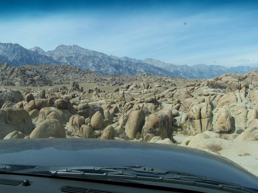
Leap of faith... We just believed that the road was down there below the hood. And it turned out that it was.


Finished up the day at an event at the Manzanar National Historic Site. Took the photo below on our way into a panel discussion about the Owens Valley, partly in relationship to the Manzanar internment camp, which involved a panel of old-timers (some in their 80s and 90s) and audience responses to questions. It was an amazing evening partly in support of the publication of Voices From This Long Brown Valley by Jane Wehry.